Your GPS works because satellites move in a planned path around Earth. Weather apps can update fast for the same reason. When you stream a TV channel or check a live map, you’re often seeing the result of careful satellite orbits.
A satellite orbit is the curved path a satellite follows around Earth. Gravity pulls it inward, while speed keeps it from falling. Mission planners pick different orbit types because they need different things, like fast coverage, strong navigation signals, or a fixed view of one spot.
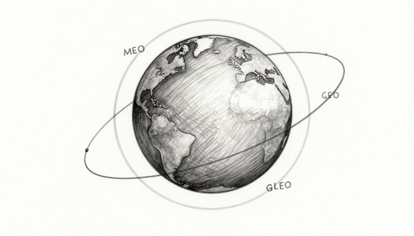
If you want the big picture, start with the most common families: LEO, MEO, GEO, plus sun-synchronous and polar orbits, and a few special paths like highly elliptical orbits. The European Space Agency explains the basic idea and why orbit choice matters in its overview of types of orbits.
Next, let’s break down each orbit in plain language, with altitudes, typical uses, and real-world examples you’ve probably heard of.
Low Earth Orbit: The Fast Lane for Internet and Imaging
LEO (Low Earth Orbit) is the “nearby” zone where satellites travel fairly close to Earth. Most LEO missions fly between about 160 km and 2,000 km altitude. Because they’re close, they move fast and complete an orbit in roughly 90 minutes.
That speed matters. It means LEO satellites can collect data quickly, then hand it off to ground stations or other satellites. It also helps LEO systems deliver low delay (latency) internet, since the signal doesn’t have as far to travel as it would from higher orbits.
LEO is also popular for imaging and science missions. From a lower height, cameras can capture sharper views. That’s helpful for tasks like storm tracking, crop monitoring, and mapping coastlines.
Here’s where modern mega-constellations come in. These are big groups of LEO satellites working together, like a swarm of bees that shares the workload. Instead of one satellite covering everything, many satellites cover parts of the globe at the same time.

For a real 2026 example, Starlink operates with a huge number of active LEO satellites. Recent KeepTrack reporting put Starlink at 10,087 active satellites around late March 2026, showing how fast LEO constellations keep growing (Starlink active satellite count).
Still, LEO isn’t perfect. The main drawback is atmospheric drag. Even at high altitude, the upper atmosphere slows satellites down over time. Because of that, operators need replacement launches more often than with higher orbits.
Why LEO Satellites Need to Swarm in Constellations
One LEO satellite sees only a slice of Earth at a time. The farther the satellite is from the surface, the larger the coverage area. In LEO, satellites are close, so each one covers a smaller region.
That’s why companies build constellations. If one satellite can’t cover the whole planet from one orbit path, hundreds or thousands can. Then, as Earth spins under them, users connect to the “next” satellite overhead.
This is also why LEO internet can improve in stages. With more satellites, there’s more time when a connection is available, and handoffs get smoother. By 2026, Starlink’s large fleet made LEO a major option for global connectivity, including for remote areas without fiber or reliable cellular towers.
Think of it like phone service in a busy city. One tower can’t handle everyone, so the network fills in coverage with many towers. In space, “towers” are satellites, and the network fills in the gaps with more birds overhead.
Medium Earth Orbit: Your GPS Guide in the Middle Ground
MEO (Medium Earth Orbit) sits between LEO and GEO. Typical altitudes range from about 2,000 km up to 35,786 km. Many MEO systems complete an orbit in several hours.
MEO is strongly tied to navigation. It offers a good balance: the satellites are high enough to cover large areas, but not so high that signals become too weak or too delayed.
That’s why you’ll often hear about MEO for systems like:
- GPS (U.S.)
- Galileo (Europe)
- GLONASS (Russia)
- BeiDou (China)
In the U.S., GPS uses about 31 operational satellites in MEO as of late March 2026. (The exact count can shift as satellites launch and retire.) These satellites beam timing and position signals that your receiver combines into a location fix.
Compared with LEO, MEO needs fewer satellites for similar global coverage. It’s not a one-to-one trade, but in general, higher altitude means a wider footprint from each spacecraft.
However, MEO also has downsides. Because it’s higher than LEO, it usually brings more signal delay than a low-altitude network. It’s also harder to keep up fast, constantly changing coverage like some LEO services.
For most navigation tasks, though, “good enough delay” plus strong geometry equals accurate positioning. If your map knows where you are in a moving car, MEO is part of the reason.
How MEO Makes Your Maps Accurate Everywhere
MEO satellites work in a system, not alone. Your phone or GPS receiver listens to multiple satellites at once. Then it uses the differences in signal arrival times to calculate your position.
Because the satellites sit in stable orbits, the geometry stays predictable. That helps receivers estimate distance precisely. Over time, improved corrections (like ground-based monitoring) also help reduce errors.
So when you drive through a city canyon or near tall buildings, MEO signals still have a fair chance to reach your device. LEO may win on speed, but navigation users usually need consistency and coverage first.
By 2026, navigation signals also face more real-world demands. Phones, cars, and safety systems want faster fixes and better accuracy. As a result, services like Galileo keep expanding and refining coverage, even when exact launch schedules vary year to year.
Geostationary Orbit: Satellites That Never Move from Your View
If LEO is a fast sprint, GEO (Geostationary Orbit) feels like hovering in place.
In GEO, satellites fly at about 35,786 km above Earth’s equator. They match Earth’s rotation period, so they appear to stay in the same spot in the sky. For users on the ground, that means less satellite movement to track.
That “fixed spot” quality makes GEO ideal for services that want steady coverage over a region. Common uses include:
- TV broadcasting (often via fixed satellite dishes)
- Weather monitoring
- Some long-distance internet services
A famous example is the U.S. GOES-R weather satellite series, which helps meteorologists monitor storms and cloud systems. GEO is also used for some satellite TV providers, where stable pointing makes the system simpler.
Here’s the GEO analogy: picture a balloon tied to one point above your yard. It stays over one area, so your view stays steady. GEO works like that, just with a much higher “balloon” and careful speed matching.
The biggest downside is cost and limits. Because GEO is so high, it needs powerful rockets to reach the right altitude and orbit. Also, GEO coverage is best over the equator region. If you live far from the equator, the satellite may sit lower in your sky, which can affect performance.
There’s also pressure from LEO internet networks. As LEO grows, some communications roles shift to lower orbits. Still, GEO remains important, especially when stable coverage is the priority.
Sun-Synchronous and Polar Orbits: Scanning Earth from Pole to Pole
Now let’s switch from “where does the satellite sit?” to “how does it pass over Earth?”
Two related orbit types often show up for imaging and science: sun-synchronous orbits (SSO) and polar orbits.
Sun-synchronous orbits (SSO)
SSO satellites typically fly around 600 km to 800 km altitude. Their key feature is the timing of the orbit. The satellite crosses the same locations at the same local solar time each day, so lighting stays consistent.
Why does that matter? Because consistent lighting makes “change detection” easier. When you compare two images from different dates, you can more confidently spot changes from land and weather, not from shifting sun angles.
Polar orbits
Polar orbits usually run from about 500 km to 1,000 km, with the satellite passing over or near the poles. As Earth rotates, the satellite gradually covers the whole planet over time.
Polar routes are great for broad Earth imaging. They also help for some forms of global surveillance and environmental monitoring.
For a helpful overview of how mission goals shape orbit choice, you can also see Types of Earth Orbits and Their Applications from eoPortal.
Sun-Synchronous Magic: Always the Same Lighting for Perfect Photos
Imagine taking a photo of a park at 9 a.m. one day, then at 3 p.m. another day. Shadows change a lot. A sun-synchronous orbit avoids that problem by aiming for repeatable lighting.
That’s why SSO is popular for monitoring:
- deforestation and land change
- urban growth
- ice and snow trends
- vegetation health
Because each pass uses similar solar angles, teams can detect real changes with fewer “false alarms” from lighting shifts.
In 2026, more small satellites are joining the mix. Operators want shorter revisit times, which means more frequent imaging. That can involve more satellites in SSO, more platforms in LEO with imaging swarms, or hybrid approaches that combine orbit types.
Polar and sun-synchronous paths also pair well with modern onboard processing. Many satellites can prioritize where to look next, based on what they saw in earlier passes. That helps the mission focus on what’s changing fastest.
For a broader explanation of orbit types used for different goals, Space Foundation has a plain-language breakdown of types of orbits.
Highly Elliptical Orbits and Other Specialized Paths
Not every mission needs to sweep Earth in a simple circle.
Highly elliptical orbits (HEO) stretch the path. The satellite moves far away at one end and much closer at the other. One well-known example is the Molniya orbit. It can reach an apogee up to around 40,000 km, with an elongated path that spends extra time over high latitudes.
That “extra time” matters for places closer to the poles, where GEO coverage can be weak. With HEO, the spacecraft can linger over certain regions during each cycle. This helps with communications where users need a stronger, longer look.
Other specialized paths exist too, depending on mission goals. Some missions use transfer orbits to reach their target. Others use tuned inclinations or repeat ground tracks for specific coverage patterns.
The big trend in 2026 is still clear. LEO constellations get most headlines because they can deliver fast coverage and frequent revisits. Even so, specialized orbits keep their value. They fit missions with unique coverage needs or specific constraints.
If you think of orbit choice like a work tool, it clicks quickly. A hammer helps with nails, but it’s not the best tool for screws. Likewise, no single orbit type wins every job.
Conclusion: Picking the Right Orbit Type for the Job
Satellite orbits come down to one simple idea: the path shapes the service. LEO gives fast coverage and sharp imaging, so it’s great for internet and data collection. MEO supports navigation with reliable signals and broad footprints. GEO stays fixed from one view, so it works well for TV and steady regional coverage.
For Earth imaging, sun-synchronous and polar orbits offer repeat passes, consistent lighting, or wide coverage. Meanwhile, highly elliptical orbits fill niche needs, especially for high-latitude communications.
In March 2026, the biggest change you can see is the rise of LEO “swarm” networks. Active fleets already exceed 10,000 satellites for major constellations, and total active satellites are heading above 15,000 by the end of the year. That growth brings new challenges too, like space traffic management and the need for safe coordination.
So, what orbit type intrigues you most: fast LEO imaging, GPS-style MEO navigation, GEO’s fixed view, or the repeat lighting of sun-synchronous passes? Share your pick and leave a comment with why.