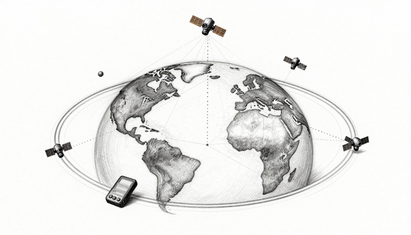
Ever wonder how your phone can show you exactly where you are, even when you’re deep in a new neighborhood? That power comes from GPS satellites, a moving network overhead that sends precise radio signals. As you drive, hike, or run, your device listens, measures timing, and converts it into location.
Here’s the key idea: satellites do not “know” where you are. Instead, they broadcast signals whose timing and position are known. Your receiver then uses those signals to figure out your distance from multiple satellites, and finally your exact point on Earth.
In March 2026, there are 31 operational GPS satellites in orbit, part of a larger system designed to keep coverage strong. The rest is math and coordination, plus a little help from ground control and advanced receivers.
Next, you’ll see how the satellite fleet stays in place, how signal timing becomes distance, and how trilateration turns distances into an exact spot. You’ll also get a few myth-busters, so your GPS makes sense when things get weird.
Meet the GPS Satellite Fleet Circling Our Planet
GPS works because the satellite system is always “in view” from somewhere on Earth. Satellites orbit in medium Earth orbit, roughly 20,000 km up, and they circle the planet in a pattern that repeats. That means your receiver can usually “see” multiple satellites at once.
Think of it like having a team of watchers spread across the sky. If you can spot enough watchers, you can triangulate your position. GPS is built so that this happens often, even when you’re moving.

To get a sense of how the constellation is arranged, NASA publishes easy-to-use visuals for the GNSS satellite fleet. You can explore them here: NASA GNSS satellite fleet visuals.
Why So Many Satellites and Where Do They Roam?
GPS uses several orbital “lanes,” called orbital planes. With multiple planes, satellites spread out so they cover the globe. As Earth turns, your sky view changes, but the constellation is arranged to keep your odds high.
In simple terms, more satellites means your receiver can grab more signal sources. For many locations, you might see four or more satellites. Often, you’ll see nine or more, depending on your position and sky visibility.
The system also plans for reliability. Satellites age, some need time off, and launch delays happen. So the constellation is built with overlap and replacement in mind. That way, navigation doesn’t fall apart if one satellite goes quiet.
A Quick Look at the Fleet’s Health in 2026
As of late March 2026, reports show 31 operational GPS satellites in the main constellation. That matches the typical setup needed for steady worldwide navigation performance.
You might also hear about specific satellites by their SVN or PRN number. For example, recent GPS III launches have been adding more resilient signals and improved anti-jam features. Meanwhile, older satellites still help fill the geometry your receiver needs.
Also, GPS receivers don’t rely on a fixed view of the same satellites forever. They use updates like the almanac (rough orbit info) and ephemeris (precise orbit info). Those updates help your device predict where satellites will be at the time you start navigation.
The Signals That Turn Time into Distance
GPS is really a timing system with a position result. Each satellite broadcasts radio signals that include:
- The satellite’s identity (so your device knows which one it’s hearing)
- Accurate timing information
- Data that helps your receiver figure out the satellite’s exact orbit position
Your GPS device then compares what it expects to receive with what it actually receives.
GPS signals are sent on several key frequency bands, including:
- L1: 1575.42 MHz
- L2: 1227.60 MHz
- L5: 1176.45 MHz
Using multiple frequencies helps performance, especially with interference and certain signal conditions.
Atomic Clocks: The Heartbeat of GPS Accuracy
The secret sauce is time. GPS satellites carry atomic clocks that keep time extremely steadily. That steadiness matters because GPS measures distance using signal travel time.
Here’s the shortcut version: if the clock on the satellite is wrong, the distance estimate becomes wrong. And if distances are wrong, your location estimate becomes wrong too.
With atomic clock precision, the timing error can be tiny. Your receiver then uses that timing to compute how far each satellite is from you. Those distances are then fed into the next step: trilateration.
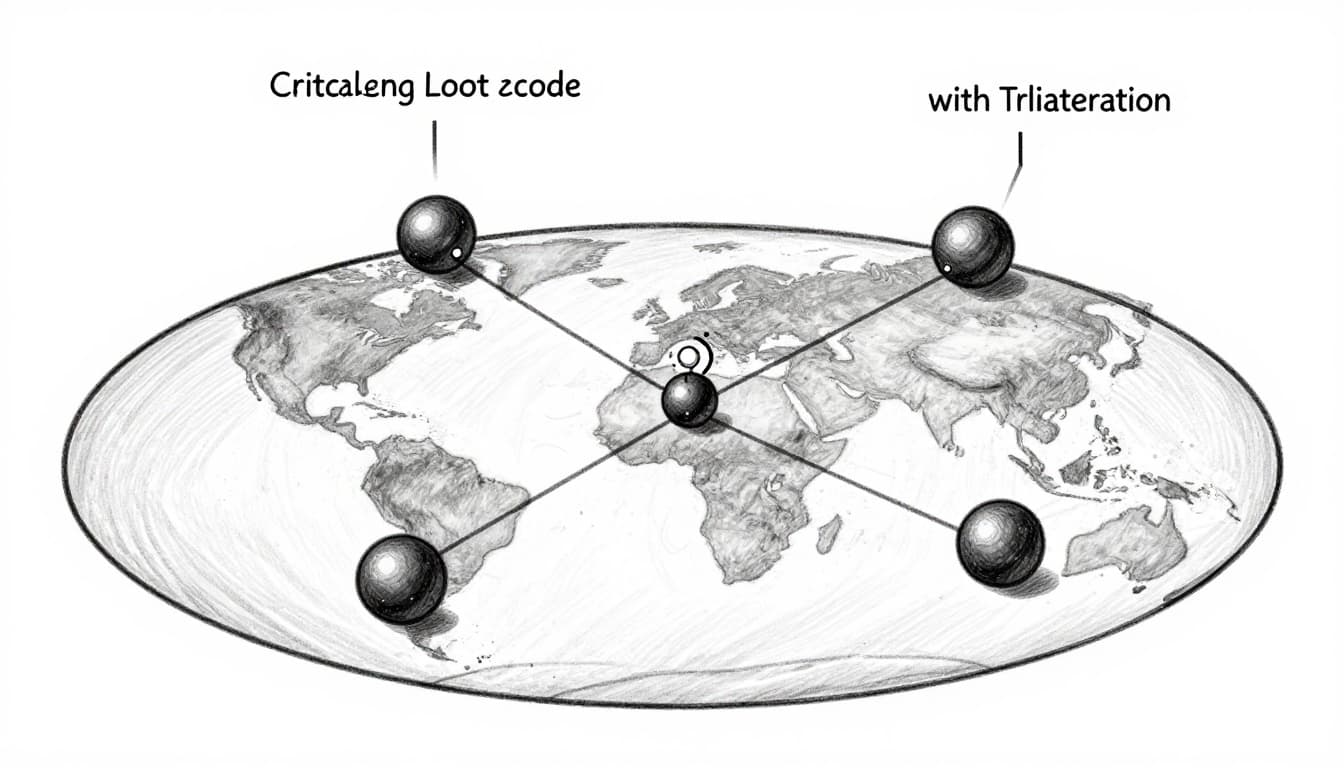
Cracking the Location Code with Trilateration
Once your receiver has distances to several satellites, it solves the location problem. It does this through a method called trilateration.
Picture each satellite as the center of a sphere. Your measured distance is the radius of that sphere. If you had perfect measurements and exact timing, one satellite would place you somewhere on its sphere. Add a second satellite, and the spheres intersect in a circle. Add a third, and you narrow to the small set of points where those intersections match.
In real GPS, there’s also a catch: your receiver clock is not as perfect as the satellite clock. Even a small clock offset can shift all distance estimates.
That’s why you need at least four satellites. The fourth one lets your device solve for the receiver’s own clock error, while also pinning down your 3D position.
For a clear, classroom-friendly explanation of the idea, see GPS.gov on trilateration.
Step-by-Step: From Signals to Your Spot on the Map
Here’s what your GPS receiver typically does when you open a maps app:
- It picks up signals from multiple satellites.
- It locks onto each signal and identifies the satellite.
- It uses timing data to compute each satellite’s distance (often via a value called pseudorange).
- It runs the trilateration math to find the single point (plus clock offset) that fits all ranges.
In other words, the “magic” is mostly geometry plus timing correction. Your phone or car runs the math fast, then shows you the result.
Ground Crew and Gadgets: The Unsung Heroes
Satellites alone are not enough. They have to stay on schedule, and they have to broadcast data that receivers can use right away.
On the ground, control systems track satellites and monitor their health. Then they upload updates so receivers can predict satellite positions accurately. It’s like giving the sky a reliable timetable.
Meanwhile, your receiver does the heavy lifting of signal processing. Modern chips can handle weak signals, multi-frequency data, and multiple satellite constellations.
How Ground Stations Keep Satellites on Track
The GPS control segment is a global network of facilities that monitor and manage the constellation. It tracks satellite transmissions, analyzes performance, and sends commands and navigation data.
You can read a high-level overview here: how GPS ground control works (Control Segment).
When ground systems update things like ephemeris data, receivers spend less time guessing. As a result, you get faster fixes and smoother tracking.
Inside Your GPS Receiver: From Chip to Directions
Your phone or car receiver has to do several jobs at once:
- Signal lock: it must distinguish GPS signals from noise.
- Measurement: it estimates timing shifts for each satellite.
- Computation: it converts timing into distances and runs trilateration.
- Output: it transforms results into a map location and speed.
Also, many devices use A-GPS (assisted GPS). That can speed up the initial satellite search by using extra info from cellular networks. Still, the GPS itself can work without cell data after it has enough signal.
Finally, modern devices increasingly support multi-GNSS, like GPS plus Galileo and others. When you use more satellite systems, you often get better reliability in tricky places.
Clearing Up GPS Confusion and Glimpsing the Future
GPS gets misunderstood because people assume it works like a simple app. In reality, it’s a full timing-and-geometry system, and it has limits.
If your GPS struggles indoors or near tall buildings, that’s normal. Signals can bounce, weaken, or get blocked.
Still, the system keeps improving, especially with newer signal types.
Top Myths About GPS Busted Wide Open
Myth 1: GPS needs cell service.
Most of the time, GPS works offline. Cell data can help you get a fix faster, but it’s not required for positioning.
Myth 2: You can find your location with three satellites.
You need at least four because the receiver clock needs its own correction.
Myth 3: GPS stopped at 24 satellites.
The constellation has expanded over time. In March 2026, there are 31 operational satellites reported in the main fleet.
Myth 4: GPS is equally reliable everywhere.
It’s weaker under heavy cover. Indoors, among dense city buildings, or near poles, you may lose lock.
Exciting Updates Powering GPS Today
GPS performance improves as newer satellites broadcast modern signals. In particular, L5 helps with accuracy and reliability. Multi-frequency and multi-constellation support also reduce the odds that interference wipes out your fix.
Meanwhile, constellation health continues to matter. Even if your device is smart, it depends on the satellites above it. That’s why updates, replacements, and ongoing monitoring are such a big deal.
The best part is how invisible this all feels. You tap “start,” and your receiver does the math in the background.
Conclusion
Satellites enable GPS because they broadcast precise signals from known orbits, and those signals carry timing information your device can measure. Your receiver then turns timing into distance, and finally uses trilateration to compute your location in 3D.
Next time you get directions on a road trip, you’ll know what’s happening overhead: a watched-over satellite fleet, atomic-clock timing, and fast receiver math. Try using maps with airplane mode on your next short hike, or test a multi-GNSS device if you have access.
When GPS works, it feels effortless. That ease comes from an amazing chain of coordination, in the sky and on the ground.